New Research Identifies the Highest-Risk Fire Corridors in the Carpathians
Researchers at Corvinus University have developed a comprehensive wildfire forecasting method that identified several fire corridors across the Carpathians. Among the most fire-prone regions are Borsod-Abaúj-Zemplén and Heves counties.

The risk of vegetation fires is increasing worldwide, and Central Europe is no exception. In a recent article published in Scientific Reports, part of the Nature portfolio, Corvinus researchers Melinda Manczinger, László Kovács and Tibor Kovács introduced a new tool for assessing fire risk in the Carpathian region.
Based on 27 variables, the authors built a database that includes information on climate, vegetation, topography and socio-economic factors. They analysed 5,173 fire events recorded between 2010 and 2020 across the 210,000 km² area of the Carpathians. Using this database, the team created a machine learning framework capable of predicting fire risk at a resolution of one square kilometre across the seven countries in the region. The model can also identify the factors that contribute to fire outbreaks.
Hungarian Counties Among the Most Vulnerable
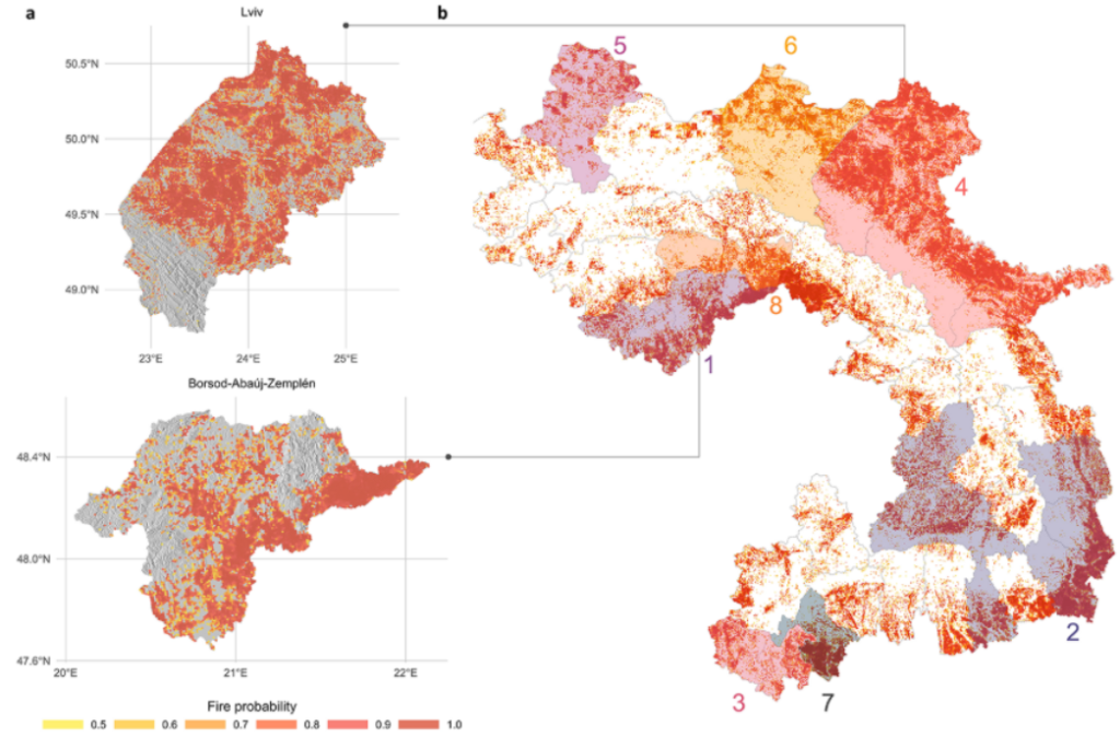
The study identified eight fire-risk clusters, several of which extend across national borders. For example, high-risk corridors were found along the Hungarian–Slovak, Serbian–Romanian and Ukrainian–Polish border areas. In Hungary, Borsod-Abaúj-Zemplén and Heves counties are among the most affected regions.
“Our main conclusion is that fire risk in the Carpathians is significant – and it is not a localised phenomenon. Effective prevention requires joint, proactive action from the affected countries. We need integrated early warning systems, coordinated fire management planning, and shared rapid response capacities,” said lead author Melinda Manczinger. She added: “A strength of our forecasting system is that it can focus on smaller areas, revealing regional characteristics that may not be visible or relevant at larger scales, but are highly significant locally.”
Human Activity and Croplands as Key Drivers
The findings show that a large proportion of fires are linked to human activity. Accordingly, the presence of cultivated land, distance from settlements and population density were among the most important predictive variables.
Topographical factors – such as elevation, slope steepness and proximity to surface water – also influence fire occurrence differently across regions. Predicted fire risk was generally higher in lower-lying areas and at the foothills of the Carpathians, which together cover roughly one-third of the study area. Distance from water bodies proved especially relevant in Serbia, Romania and Hungary. As expected, hot and dry weather further increases fire risk.
Mountain ecosystems like the Carpathians are particularly vulnerable to climate change. Drier summers and more frequent heatwaves not only increase ignition potential but also make firefighting more difficult. While fires can sometimes benefit ecosystems, the researchers warn that their growing frequency and intensity may threaten forestry, agriculture and tourism. This makes it especially important to identify fire-sensitive areas and strengthen cross-border cooperation in prevention.
The researchers’ detailed wildfire forecast maps can be viewed for the entire Carpathian region here, as well as for Borsod-Abaúj-Zemplén and Lviv counties.